In 2019 Fyfe was approached by a long-standing client to assist with the planning and reporting for a proposed State Significant Development (SSD). The project required characterisation of over 4,000 structures and buildings (SB) covering an area approximately 20kms x 22kms.
Fyfe’s NSW Survey Manager Chris Nixon and his team sought to challenge the way this would have traditionally been done (e.g. Google Earth) and instead utilised a combination of highly skilled staff and their experience to provide the client with a comprehensive dataset in a new and exciting way.
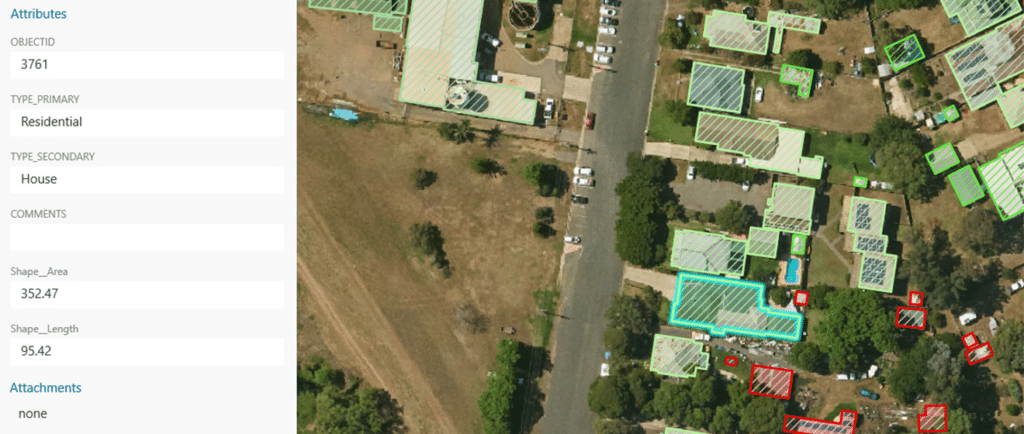
To assist with project delivery, Fyfe engaged Aerometrex to fly the entire area with LiDAR, extracting all SB within the area of interest. The SB that were identified were then automatically extracted from the dataset and set up within a GIS data collection app as polygons for field verification. Fyfe utilised in-house GIS specialists to ensure the data was accurately handled and processed as a priority for the client.
Fyfe’s surveyors equipped with 4G Panasonic Toughpads and iPads individually characterised the SB based on a pre-determined list of
12 characteristics (such as school, house, place of worship or accommodation). This process was completed by a two-person field crew over the course of a month. Difficult or inaccessible areas were characterised via a mix of techniques, such as oblique view with NearMaps, RPAS (drone) footage, realestate.com.au, or discussions with landowners and locals.
The use of GIS software-enabled Fyfe surveyors to quickly and accurately characterise the SB with real-time updates. Fyfe designed a data collection form relevant to the project, with all data collection entered and managed digitally – no physical paperwork was required.
For the final result, Fyfe provided their client with an interactive map of an astounding 4,425 SB accurately characterised. From this, the client could proceed with further analysis and assessment of any impacts their SSD may have on local communities. Fyfe also applied a forward-thinking approach by liaising with relevant local councils to consider approved development applications from the past five years which perhaps hadn’t started construction and therefore weren’t captured via the above process.
Once the scope was set and methodology approved, the LiDAR and characterised dataset were delivered within two months. The traditional method for delivering this project without LiDAR and GIS would have taken substantially longer and had a much higher margin for error – such as relying on outdated maps, missing SB or inaccurate labelling.
NSW Survey Manager, Chris Nixon, is extremely happy with how the dataset came together. “It worked out perfectly, it is an awesome dataset. It has been a satisfying project from start to finish, doing exactly what we said we would do.” The opportunities in this space are limitless.
As an alternate example, environmental assessments could utilise similar GIS technology for rehabilitation works or growth monitoring. Multispectral cameras could be flown over an area of interest, providing data to classify weeds or additional areas requiring further investigation or action.
Through the use of skilled individuals and technology, Fyfe was able to deliver this project in a far more efficient and effective manner, saving time and money for the client.